

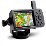
GARMIN GPSMAP 376C PORTABLE COLOR GPS CHARTPLOTTER WITH XM SATELLITE


$270.00
- Description
- Additional information
- Reviews (0)
Description
Sonar Capability
In addition, the GPSMAP 376C can also receive sonar data through the Garmin’s “black box” sounder, which offers 4,000 watts of power peak-to-peak (500 watts RMS) in a dual-frequency transducer (purchased separately).
GPSMAP 376C Features:
- Can display animated NEXRAD weather radar and forecasts, current conditions, wave data, surf temperatures, and much more. (Satellite weather and audio are only available within XM’s signal coverage area.)
- 3.8-inch diagonal, 480 x 320 pixel, 256-color TFT screen with adjustable LED backlight
- Unit dimensions: 5.7″W x 3.2″H x 1.9″D
- Stores up to 3,000 user waypoints, 50 reversible routes (300 waypoints per route)
- 10,000 point automatic track log; 15 saved tracks
- Rechargeable lithium battery offering 4-15 hours of use (depending on backlight settings)
- Alarms: anchor drag, arrival, off-course, proximity waypoint, and clock
- Water resistant to IEC 60529 IPX7 standards (submersible in one meter of water for 30 minutes)
Package Includes:
- GPSMAP 376C
- Americas: Americas Autoroute
- GXM 30 smart antenna
- Marine mount
- GXM 30 pole mount
- Rechargeable lithium-ion battery
- A/C charger
- Power/data cable
- USB cable
- 2 meter GXM 30 extension cable
- Owner’s manual
Additional information
| Brands | Garmin |
|---|


Reviews
There are no reviews yet.