

GARMIN GPSMAP 3210 PRE-LOADED BLUECHART NETWORK CHARTPLOTTER


$640.00
- Description
- Additional information
- Reviews (0)
Description
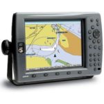
One look at the GPSMAP 3210, and you’ll know you’ve found a chartplotter big enough for the waterfront. For boaters wanting a large-format display along with the benefits of a seamless plug-and-play system and built-in maps for U.S. coastal areas, including Alaska and Hawaii, this is your plotter. The GPSMAP 3210’s huge 10.4-inch diagonal display delivers vivid color and detail – even in direct sunlight. High-speed microprocessors make for extremely fast redraw and response rates. It can serve as a standalone plotter or network with other MFDs and sensors to deliver XM weather, radar and sonar. The 3210 accepts up to 2 video inputs so you can watch the engine room or monitor activity on deck. Convenient soft key functions allow you to assign a feature such as map declutter to a specific key.
The GPSMAP 3210, along with the 3205 & 3206, come preloaded with the latest U.S. coastal marine maps utilizing BlueChart g2 technology. This new generation of BlueChart features a smoother layering and better integration of map graphics for easy panning, scrolling and zooming. It also offers a choice between a 3D “mariner’s-eye-view”, or the familiar 2D direct-overhead view – to make chart reading and orientation easier.
What’s in the Box:
- GPSMAP 3210
- Preloaded U.S. marine detailed maps (g2 technology)
- GPS 17 WAAS-enabled sensor
- Power/data cable
- Bail mount
- Protective cover
- Template for flush mounting
- Owner’s manual
- Quick reference guide
- Installation guide
Additional information
| Brands | Garmin |
|---|


Reviews
There are no reviews yet.