

GARMIN GPSMAP 3206 PRE-LOADED BLUECHART NETWORK CHARTPLOTTER


$420.00
- Description
- Additional information
- Reviews (0)
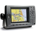
Description
For boaters wanting the benefits of a seamless plug-and-play system and built-in maps for U.S. coastal areas, including Alaska and Hawaii, the GPSMAP 3206 is right on target. This plotter has all the features of the 3210, just on a slightly smaller scale. The 6.4-inch MFD with sunlight-readable color shows incredible contrast and detailing, even in direct sunlight. It can serve as a standalone plotter or network with other MFDs and sensors to deliver XM weather, radar and sonar. The 3206 accepts up to 2 video inputs so you can watch the engine room or monitor activity on deck. Convenient soft key functions allow you to assign a feature such as map declutter to a specific key.
The GPSMAP 3206, along with the 3205 & 3210 come preloaded with the latest U.S. coastal marine maps utilizing BlueChart g2 technology. This new generation of BlueChart features a smoother layering and better integration of map graphics for easy panning, scrolling and zooming. It also offers a choice between a 3D “mariner’s-eye-view”, or the familiar 2D direct-overhead view – to make chart reading and orientation easier.
Additional information
| Brands | Garmin |
|---|


Reviews
There are no reviews yet.