

SI-TEX GPS-90 GPS TRACK PLOTTER


$200.00
- Description
- Additional information
- Reviews (0)
Description
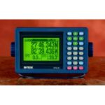
The Si-Tex GPS-90 GPS Track Plotter features full keypad entry- at an entry-level price!
- Competitive models offer only arrow keys to input data. Requiring up to 77 key touches to input a single waypoint. With the GPS-90, waypoint entry is quick, no tedious scrolling is required.
- Large, easy-to-read backlit LCD display and backlit softkey controls allow instant mode selection.
- Graphic and digital compass displays for heading and bearing information.
- Electronic Fairway display shows vessel’s rhumbline course, cross-track error, and progress to desired waypoint.
- North up, X-Y axis plotter shows history of the vessel’s track on a wide selection of ranges from 150 feet to 20 NM to help you accurately retrace previous trips. 2000 plotting points available.
- Advanced continuous tracking “MaxView” receiver processes data from up to 11 GPS satellites for accurate position updates every second.
- Differential beacon receiver offers repeatable accuracy to 2-10 meters.
- Mobile cursor on the plotter display pinpoints position information of navigation landmarks.
- Transfer your favorite Loran fishing hotspots with the built-in automatic Lat/Lon to LOP Conversion Program.
- 400 nameable waypoints and every-memory storage let you keep track of all your favorite fishing and cruising spots.
- “Quick” waypoint feature allows for immediate position entry without assigning a permanent memory.
- MOB (man-overboard) display stores precise position in Lat/Lon and provides a graphic visual perspective of emergency situations plus continuous updates of range and bearing.
- NMEA 0183 data port allows simple connection to charting systems, autopilots, radars and depth sounder. A wide array of selectable output sentence information insures compatibility with most other devices.
- Rugged, weatherproof construction to withstand the harsh marine environment.
| SI-TEX GPS-90 SPECIFICATIONS | |
| GPS RECEIVER | |
| Receiving Frequency | 1575.42 MHz + 1MHz |
| Receiving Channel | Parallel “MaxView” tracks 11 satellites |
| Receiving Code | Receiving Code |
| Sensitivity | Better than –130dBm (elevation angle: 5 or over) |
| Tracking Speed | 200 knots maximum |
| Accuracy (at HDOP 3 or less by C/A code) | Position: 2 to 10 meters RMS*(DGPS On), 15 meters (with DGPS Off) Velocity: 0.1 knot RMS (DGPS On) |
| GPS DISPLAY | |
| Display | LCD backlit by electroluminescent cell (128 x 64 pixels) |
| Display Modes | NAV1, NAV2, NAV3, PLOT, MOB, MENU |
| Track Display | Display Range: 0.025, 0.05, 0.1, 0.2, 0.5, 1, 2, 5, 10, 20 nm (sm, km) |
| Usable Ground: | Within 80 in latitude |
| Plotting Interval: | 10, 20, 30 seconds, 1, 3, 5 minutes, 0.1, 0.5 nm (sm, km) |
| Plotting Capacity: | 2000 points |
| Position Data Display | Latitude/longitude in increments of 1/1000 minute, converted Loran C LOP, Loran A LOP or Decca LOP |
| Navigation Displays | Speed, course, velocity made good/course made good/elapsed time, altitude, distance/bearing/cross-track error/CDI/time to go to waypoint, total time to go and distance on route, DOP value, present time (UTC or LTC), satellite status, beacon receiving status, distance/bearing between two points, MOB display |
| Waypoint/Event Memory | A total of 400 waypoints with alphanumeric identifiers |
| Route Memory | 20 routes of 20 waypoints each (reversible) |
| Position Update | Every second |
| Alarms | Position Compensation Latitude/Longitude, Loran C LOP, Loran A LOP, Decca LOP or Datum |
| Magnetic Compensation | Auto or manual |
| Parameters | Loran C LOP/Loran A LOP/Decca LOP conversion, memory of waypoints and name (up to 10 letters), selection of measuring unit (nm, km, sm), antenna height, averaging (smoothing) factor, positioning mode (2D or 3D automatic selection), selection and registration of beacon station |
| Input Data Format | NMEA 0183, NMEA 0183, RTCM SC-104 |
| Output Data Format | NMEA 0183 |
| Memory Protection | Memory Protection |
| Power Requirements | 11 40V DC, less than 5W |
| Operating Temperature Display Unit: | 5 to 131 F (-15 to +55 C) |
| Antenna Unit: | -22 to 131 F (-25 to +55 C) |
| Case Dimensions | 7.5″W x 4.75″H x 2.7″D |
| Case Weight | 2.1 lbs. (GPS-90D), 1.9 lbs. (GPS-90) |
| Antenna Weight (GPS) | .4 lb. |
| Antenna Coupler Weight (DGPS) | 0.9 lb. |
| Optional “H” Filed Antenna Weight | 2.7 lbs. |
Additional information
| Brands | Si-Tex |
|---|


Reviews
There are no reviews yet.