

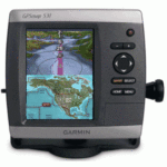
GARMIN GPSMAP SUPER COMBO 531S W/ COAST CHARTS & DUAL BEAM TRANSDUCER


$270.00
- Description
- Additional information
- Reviews (0)
Description
Garmin GPSMAP 531S Combo – Includes dual beam transducer
Features a large ultra-bright 5″ QVGA display along with an improved high-speed digital design for faster map drawing and panning speeds Plus, these waterproof units have a high-sensitivity internal GPS receiver, so mariners will always know their opsition on the water. They are ready to go with built-in cartography for inland U.S. waters (over 14,000 lakes) and Garmin’s proven easy-to-use interface designed to help you navigate the waters with ease.
Features and Specifications:
- Large, ultra-bright 5″ diagonal QVGA display, 234 x 320 pixels – over 800 nits of brightness
- Preloaded with charts for over 14,000 U.S. lakes and navigable rivers
- Compatible with GXM 51 for XM Satellite Radio and XM WX Satellite Weather
- Built-in high-sensitivity GPS receiver
- High-speed processor for fast screen redraws and smooth panning
- Two NMEA 0183 I/O ports
- Streamlined user interface makes it simple to select modes and features
- Single SD memory card slot for BlueChart g2 Vision cards, as well as saving waypoints, routes and tracks to an SD card
- Optional BlueChart g2 Vision cards provide marine chart detail and enhanced navigation features like Auto Guidance, satellite imagery, 3-D Mariner’s Eye View and 3-D Fish Eye View
- Backlit keypad for easy operation in low light conditions
- Unit dimensions: 5.9″H x6.4″W x 2.9″D
- Power output: 400 watts (RMS) 3200 watts (peak to peak), dual beam
- Depth: 900 feet/300 meters (dual beam)
- Dual beam transducer – 80 kHz (45 degrees), 200 kHz (14 degrees) for maximum freshwater performance
- Patented transom/trolling mount transducer
- UltraScroll high rep rate sonar provides lightning-fast screen updates
- AutoGain technology enhances target visibility
- See-Thru technology shows weak and strong returns simultaneously
- Water temperature log graphically records water temp data
- A-scope
- Round flasher display mode
- Whiteline
- Adjustable depth line helps gauge desired fishing levels and bottom clearance
- Split zoom display offers a closer look at fish targets and bottom structure
- 2X, 4X, and bottomlock zoom
- Adjustable keel offset
- Alarms for fish size, shallow water, deep water, and low batteryPackage Includes:
- GPSMAP 531s
- HXUS039R BlueChart Card (Same coverage as GPSMAP 541s)
- Transom Mount Transducer
- Tilt/swivel mount
- Protective front cover
- Power/data cable
- Documentation
Additional information
| Brands | Garmin |
|---|


Reviews
There are no reviews yet.