

GARMIN GPSMAP 541 COLOR GPS CHARTPLOTTER WITH PRE-LOADED COASTAL MAPS


$320.00
- Description
- Additional information
- Reviews (0)
Description
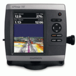
GPSMAP 541 Chartplotter
Featuers a large ultra-bright 5″ QVGA display along with an improved high-speed digital design for faster map drawing and panning speeds. Plus, these waterproof units have a high-sensitivity internal GPS receiver, so mariners will always know their position at sea. They are ready to go with built-in BlueChart g2 marine cartography of the coastal United States – including Alaska, Hawaii, and Explorer Chart data of the Bahamas. Mariners can navigate the waters of with ease knowing that these new units include Garmin’s proven easy-to-use interface design.
Features and Specifications:
- Large, ultra-bright 5″ diagonal QVGA display, 234 x 320 pixels – over 800 nits of brightness
- NMEA 2000 certified for seamless integration with the Garmin marine lineup
- Preloaded worldwide marine basemap
- Compatible with GXM 51 for XM Satellite Radio and XM WX Satellite Weather
- Built-in high-sensitivity GPS receiver
- High-speed processor for fast screen redraws and smooth panning
- Streamlined user interface makes it simple to select modes and features
- Single SD memory card slot for BlueChart g2 Vision cards, as well as saving waypoints, routes and tracks to an SD card
- Optional BlueChart g2 Vision cards provide marine chart detail and enhanced navigation features like Auto Guidance, satellite imagery, 3-D Mariner’s Eye View and 3-D Fish Eye View
- Backlit keypad for easy operation in low light conditions
- Unit dimensions: 5.9″H x6.4″W x 2.9″D
Additional information
| Brands | Garmin |
|---|


Reviews
There are no reviews yet.