

GARMIN GPSMAP 536 COLOR GPS CHARTPLOTTER WITH PRE-LOADED INLAND MAPS


$360.00
- Description
- Additional information
- Reviews (0)
Description
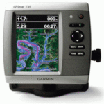
GPSMAP 536 Chartplotter
Even in bright sun, it is easy to see the clarity of the GPSMAP 536. These brilliant 5″ VGA displays give you a sharp, clear picture, and the fast processor makes for smooth panning and screen redraws as you scroll. Plus, these waterproof units have a high-sensitivity internal GPS receiver, so mariners will alwyas know their position on the water. They are ready to go with built-in cartography for inland U.S. waters (over 14,000 lakes) and Garmin’s proven easy-to-use interface is designed to help you navigate the open waters with ease.
Features and Specifications:
- Bright, crisp 5″ diagonal VGA display, 480 x 640 pixels – over 800 nits of brightness
- NMEA 2000 certified for seamless integration with the Garmin marine lineup
- Preloaded with charts for over 14,000 U.S. lakes and navigable rivers
- Compatible with GXM 51 for XM Satellite Radio and XM WX Satellite Weather
- Built-in high-sensitivity GPS receiver
- High-speed processor for fast screen redraws and smooth panning
- Two NMEA 0183 I/O ports
- Streamlined user interface makes it simple to select modes and features
- Single SD memory card slot for BlueChart g2 Vision cards, as well as saving waypoints, routes and tracks to an SD card
- Optional BlueChart g2 Vision cards provide marine chart detail and enhanced navigation features like Auto Guidance, satellite imagery, 3-D Mariner’s Eye View and 3-D Fish Eye View
- Backlit keypad for easy operation in low light conditions
- Auto-dimming display
- Unit dimensions: 5.9″H x6.4″W x 2.9″D
Additional information
| Brands | Garmin |
|---|


Reviews
There are no reviews yet.