

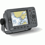
GARMIN GPSMAP 3005C CHARTPLOTTER FOR MARINE NETWORK


$330.00
- Description
- Additional information
- Reviews (0)
Description
Garmin GPSMAP 3005C Features:
- WAAS-enabled, 12 parallel channel GPS sensor with 30-foot cable
- Use individually or connect and control multiple displays and sensors with built-in high-speed network
- View XM WX Satellite weather overlays with optional GDL 30/30A weather/audio receiver
- Add sonar with optional GSD 20 remote sounder; dual-frequency, 500 watts RMS
- Unit dimensions: 7.8″ W x 4.7″ H x 3.0″ D (197 mm x 120 mm x 75 mm)
- Single, front-loading card slot accepts pre-programmed data cards
- 5″-diagonal, 256-color TFT, full VGA, sunlight-readable display
- Weighs approximately 1.8 lbs.
- Backlit display and keypad
- Permanent user data storage; no memory battery required
- Meets rigid IEC 60529 IPX7 submersible standards
- Built-in worldwide basemap showing cities, interstates, coastline detail and U.S. tide stations
- Compatible with Garmin’s BlueChart marine cartography and most MapSource products, including Fishing Hot Spots and Minnesota LakeMaster
- 4,000 user waypoints with name and graphic symbol; 50 reversible routes with 300 waypoints/route
- 10,000 point automatic track log; 15 saved tracks let you retrace your path in both directions; 700 points/saved track
- Position formats include Lat/Lon, UTM, Loran TDs, Maidenhead, MGRS, and user grid
- Audible alarms for anchor drag, arrival, off-course, shallow water, deep water, proximity waypoint, clock, and battery
- Large-numbers option for easy viewing
- Course and speed filtering
- Built-in celestial tables for sun and moon calculations
Package Includes:
- GPSMAP 3005C
- GPS 17 WAAS-enabled sensor
- Power/data cable
- Bail mount
- Unit cover
Additional information
| Brands | Garmin |
|---|


 BLACK BOX ECHOSOUNDER MODULE F/NAVNET")


Reviews
There are no reviews yet.